Canals, Navigable Rivers and Commercial Ports That Were Accessible to Humber Sloops.
 |
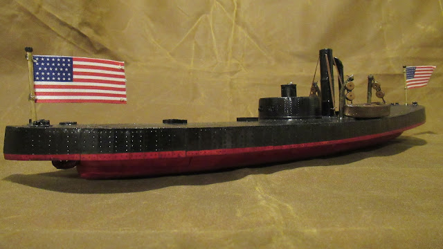
| Humber sloop, a sailing barge of Lincolnshire and Yorkshire, seen from the starboard side. |
Humber sloops were merchant vessels that traded along the inland waterways of Yorkshire, Lincolnshire, Derbyshire and Nottinghamshire as well as the East Coast of England. These flat-bottomed barges, able to beach on the sandbanks and mudflats at low tide, were designed to operate in the shallow waters of the Humber Estuary as well as the tidal sections of its tributaries. A typical sloop was equipped with a single mast, a triangular headsail, a quadrilateral mainsail, a pair of leeboards and a stern-mounted rudder that was steered by a tiller. Advances in metallurgy, occurring during the late eighteenth and early nineteenth centuries, made it possible to construct these vessels from iron while steel became the favoured building material at the turn of the twentieth century. Anti-fouling paint, containing toxic biocides such as black copper(II) oxide or red lead(II,IV) oxide, was used to discourage marine life from colonising the hull. Sloop-rigged barges, constructed at shipyards along the River Humber, were built into the nineteen-thirties but disappeared when diesel engines and screw propellers replaced sails during the Second World War.
What Is The Difference Between Humber-Sized Barges and Sheffield-Sized Vessels?
Pound locks, consisting of a chamber with a gate on either end, aid navigation along canals and rivers by raising or lowering water levels while the size of vessel that can proceed along the waterway is determined by the dimensions of the locks. The four main tributaries of the Humber Estuary, used for navigation purposes since prehistoric times, were fitted with locks in order to allow inshore craft to reach stretches of river that were inaccessible due to the height on the terrain. Navigation work was performed on the Don, Ouse, Trent and Ancholme during the seventeenth, eighteenth, nineteenth and twentieth centuries in order to keep these rivers open to commercial traffic. National Historic Ships UK maintains that only boats of sixty one feet, six inches, could travel the entire length of the Sheffield and South Yorkshire Navigations due to the size of the locks. Naburn Lock, opened in seventeen fifty-seven on the River Ouse, blocked larger craft from accessing York because its dimensions were similar to that of a Sheffield-sized lock. A distinction arose, therefore, between inshore craft that traded on the rivers and coastal vessels that sailed between estuarial ports.
How Far Inland Could Humber Sloops Travel?
Estuary-sized barges, such as Humber sloops, had been unable to access the River Don or the Yorkshire Ouse due to the size of the locks. The earliest locks to be installed on the Aire and Calder Navigation, installed in the eighteenth century, were too small to accommodate either Sheffield-sized or Humber-sized vessels. Improvements to the River Ancholme, by comparison, enabled estuary-sized barges to access the agricultural heartlands of Lincolnshire from as early as the seventeen sixties. Efforts to open the River Trent to greater volumes of commercial traffic, beginning in the seventeen eighties, allowed Humber sloops to reach the inland ports of the East Midlands by the end of the eighteenth century. Attempts to modernize the commercial waterways that were connected to the Humber Estuary, beginning in the eighteen sixties, led to the extension of locks and to the improvement of existing navigation channels. The excavation of new cuts, such as the New Junction Canal, created additional links between the existing waterways. Humber sloops, taking advantage of these improvements, could travel further inland than they ever had before.
Aire and Calder Navigation, Yorkshire.
The River Aire was made navigable between Leeds and Airmyn, where the river meets the Yorkshire Ouse, during the early seventeenth century. Similar work was performed on the River Calder that allowed boats to travel between Castleford, which is situated on the confluence of the Aire and Calder, and Wakefield. Textiles, woven from wool and later from cotton in Leeds and Wakefield, made Yorkshire prosperous and business interests in the industrial towns decided that it was more efficient to transport their products by water than it was by land. An Act For the Making and Keeping Navigable the Rivers Aire and Calder in the County of York received Royal Assent on the fourth of May, sixteen ninety-nine, and led to the excavation of new cuts as well as the installation of weirs and locks. Coal, extracted from West Yorkshire collieries, was transported to the Humber ports via the navigations and increases in traffic led to the locks being extended in the eighteen sixties. Larger vessels, including Humber sloops, could pass through the two hundred feet locks on the Leeds branch as well as the one hundred and forty-one feet lock on the Wakefield section.
New Junction Canal, Yorkshire.
The New Junction Canal, opened in nineteen hundred and five, was the last of the commercial waterways to be opened in Britain. Limitations to the amount of traffic that could pass along the Sheffield and South Yorkshire Navigations, which comprised the engineered section of the River Don and three connecting canals, put it at a disadvantage to its competitors such as the Aire and Calder Navigation that was equipped with locks that could accommodate larger boats. Proposals to expand the locks along the Sheffield and South Yorkshire Navigation, formed in eighteen eighty-eight, would have been too expensive to implement and it was decided to excavate a new cut instead. The new canal, linking the River Don with the Stainforth and Keadby Canal as well as the River Aire, was a joint-funded project and proceeded after the Aire and Calder and River Dun Navigations Junction Canal Act 1891 was made into law. The canal's only lock, located near the village of Sykehouse, could accommodate vessels of up to two hundred feet in length and twenty feet in beam. Humber sloops, passing through the New Junction Canal, were able to travel from the River Aire to the River Don.
River Trent, East Midlands.
The River Trent, the third-longest watercourse in Britain, is tidal from its confluence with the Yorkshire Ouse until it reaches Cromwell Lock and has been navigated for centuries. Shardlow, on the Derbyshire stretch of the river, marks the furthest point at which boats can travel along the navigable waterway that merges with the Yorkshire Ouse at Trent Falls. Mark Patterson, on pages four and five of A History of Trent Basin which details the various ways in which the river has been used over the centuries, states that William Jessop improved navigability along the waterway as far as Gainsborough during the late eighteenth century. The Trent Navigation Company, lasting from seventeen eighty-three until the beginning of the Second World War, was created after the passing of the Trent Navigation Act 1783 and was responsible for improving conditions along the river for commercial traffic. Trade links between Nottingham and Kingston-upon-Hull, following the course of the Trent, brought prosperity to both settlements. Humber sloops, having reached Nottingham, may have found Castle Lock too narrow to allow them further passage along the river.
River Ancholme, North Lincolnshire.
The River Ancholme, accessed via South Ferriby Lock in North Lincolnshire, could be navigated by vessels of up to eighty feet in length and nineteen feet in beam as far as Harlam Hill Lock. An Act of Parliament was secured on the twentieth of May, seventeen sixty-seven, to improve the river for drainage as well as navigation. Sir John Rennie the Younger, whose father had been appointed the chief engineer on the navigation before him, oversaw the construction of a lock at South Ferriby that had larger dimensions than those which were found on the River Don. The Inland Waterways Association claims that South Ferriby Lock, situated on the confluence of the River Ancholme and the Humber Estuary, can accommodate vessels of eighty feet in length and nineteen feet in beam while official government sources state that the lock can accommodate vessels of sixty-eight feet in length and eighteen feet in width. Harlam Hill Lock, built in eighteen twenty-seven by Sir John Rennie the Younger and accessible to boats of no more than forty feet in length, could be negotiated by neither Humber-sized nor Sheffield-sized barges.
River Ouse, Yorkshire.
It is known, due to archaeological evidence of grain warehouses in York that date from the second century, that the Yorkshire Ouse has been navigable since Roman times. The river, tidal until the first locks were installed in the middle of the eighteenth century, remained an important commercial artery until the gradual deposition of silt created shoals that made the river difficult to navigate. York, a major exporter of wool from the Medieval period onwards, faced economic decline due to the deterioration of the river and proposals were made to improve conditions along the waterway for navigation. In the seventeenth century the river was dredged, obstacles were removed and a series of and weirs and locks were constructed. A new deep water lock at Naburn, opened in eighteen eighty-eight, allowed barges of up to one hundred and fifty feet to travel the Yorkshire Ouse as far as Linton Lock. Humber sloops, accessing the Yorkshire Ouse at Trent Falls, were able to reach York after the construction of the second lock at Naburn had been completed and contributed to the economic rejuvenation of the city.
Which Commercial Ports Beyond the Humber Were Visited By Estuary-Sized Sloops?
Sloop-rigged trading barges, sailing from ports such as Grimsby or Kingston-upon-Hull, were known to leave their native estuary to visit the East Coast of England as well as the European Continent. John Leather claims on the eighty-first page of The Gaff Rig Handbook: History, Design, Techniques, Development that Humber sloops traded with ports along the East Coast of England. East Anglian seaports, including those situated along the banks of the Wash, were often visited while the rivers Thames and Tyne were occasional destinations. Nicholas Leach explains in the third chapter of Lifeboats of the Humber: Two Centuries of Gallantry that a sloop, going by the name of Chesterfield and sailing from King's Lynn, was wrecked at the Inner Binks while transporting gravel to Kingston-upon-Hull. The sloop sank on the ninth of September, nineteen fourteen, and may have procured its gravel from Spurn before it embarked on its final journey. Spurn, situated at the mouth of the Humber Estuary, is a spit of land that projects into the North Sea and flat-bottomed sloops would take the ground at low tide in order to be loaded with sand or gravel that was destined for the construction industry.
Have Any Estuary-Sized Humber Sloops Survived Into The Present Day?
Of the three remaining Humber sloops, all of which are registered by National Historic Ships UK, only Phyllis was built to estuarial dimensions while Amy Howson and Spider T are Sheffield-sized barges. The Ministry of Defence, conscious of the need to modernize the nation's merchant fleet on the eve of the Second World War, funded the conversion of Humber sloops from sailing vessels to motor barges. Phyllis was equipped with an inboard diesel engine, driving a single screw propeller, in the nineteen forties and her masts and sails were removed following the conversion. A fourth vessel, going by the name of Annie Barraclough and measuring seventy-one feet by fifteen feet, was rigged as a sloop before it was registered as a motor barge in nineteen forty-six. William Henry Warren, having acquired a shipyard at New Holland, built Phyllis in nineteen hundred and seven while Annie Barraclough was constructed at Hessel in eighteen ninety-eight by Henry Scarr. Both vessels, built of riveted iron plate, carried military supplies for the duration of the war. Below is a list of ports, situated along the River Humber and its tributaries, that were visited by iron or steel-hulled estuarial sloops.
Grimsby, North East Lincolnshire.
Grimsby, located on the South Bank of the Humber Estuary, has a proud maritime heritage that dates back to the Medieval period while the foundations of its current port complex were established in the eighteenth and nineteenth centuries. The port, possessing two fishing docks, was home to a large trawling fleet while merchant vessels would arrive to discharge their cargo in the town's commercial docks. Trading sloops, of both estuary-sized and Sheffield-sized dimensions, made frequent visits this seaport. National Historic Ships UK states that Phyllis transshipped a variety of goods at the commercial docks at Grimsby, including citrus fruits and dairy products, during World War Two and it is likely that these cargoes were lightered from merchant ships that had braved the perilous journey across the Atlantic. The presence of factories, such as Dixon's Paper Mill and Victoria Flour Mills, on the waterfront allowed raw materials to be transported to these production centres by barge. Coal, which fuelled the steam-engines that powered the factories, could be carried from the Yorkshire mines to the Lincolnshire town by Humber-sized vessels.
Immingham, North East Lincolnshire.
Immingham Docks, situated in North East Lincolnshire and built in the early twentieth century, provided the Great Central Railway (GCR) with a rail-to-ship loading facility on the South Bank of the Humber Estuary. The deepwater dock was opened on July the twenty-second, nineteen twelve, by King George the Fifth and included two double-tracked railway jetties as well as three hydraulic gates that allowed ships to enter the port complex. The Port of Immingham, created after the Humber Commercial Railway and Dock Act was passed in nineteen hundred and four, was built to facilitate the export of coal alongside other cargoes. A significant amount of the black mineral, destined to be shipped to domestic and foreign markets, was transported to the Lincolnshire town by rail but the Yorkshire waterways remained busy with traffic that moved between the collieries and the Humber ports for much of the twentieth century. National Historic Ships UK claims that coal, mined at Bentley Colliery in South Yorkshire, was transported by Phyllis along the New Junction Canal and that the iron-hulled barge made frequent visits to Immingham.
Kingston-upon-Hull, East Riding of Yorkshire.
Kingston-upon-Hull, the current home to the Humber Keel and Sloop Preservation Society, first came to prominence as a trading port during the thirteenth century due to the wool trade as well as the patronage of King Edward the First of England. It became, over the following centuries, the most important port in the region and came to surpass York itself in terms of maritime trade. Humber sloops, unlike their cousins the keels which are believed to date back to the Early Medieval period, first appeared at Kingston-upon-Hull during the eighteenth century and may have been influenced by Dutch trading vessels that used to arrive at the port. It is believed, from evidence presented in contemporary paintings, that the sloop rig first emerged in the Netherlands and that the commercial links between ports on the Humber and ports in the Low Countries influenced the development of sailing vessels in the Yorkshire as well as the Lincolnshire areas. The Low Countries, Flanders in particular, were major importers of English wool while increased coal production in the eighteenth and nineteenth centuries would also have found buyers in overseas markets.
Goole, West Riding of Yorkshire.
Goole, the furthest inland port in the East of England, began its rise to prominence in the early nineteenth century when the Aire and Calder Navigation Company built a canal that linked the fledgling town to Leeds. The Knottingley to Goole branch of the navigation, according to the Canal and River Trust, opened in eighteen twenty-six and the company built several docks that were intended for the loading and unloading of cargo. An earlier village, which became known as Old Goole, had existed in the area since Dutch engineers diverted the course of the River Don in the seventeenth century in order to drain Hatfield Chase. Cornelius Vermuyden, under the patronage of King Charles the First, created a junction between the Don and the Ouse in order to drain the marshlands that had surrounded the old river. The diverted watercourse, known as the Dutch River, joined the River Ouse and a settlement was formed at the confluence of the two rivers. Coal, arriving from the Yorkshire collieries for transshipment at the Goole docks, was transported in estuary-sized vessels and Humber sloops would have been among the vessels used to transport this important cargo.
Blog post was last updated on the 18th of March, 2023, which was a Saturday.

Comments
Post a Comment